
In October 2018, we made our very first expedition to Anak Krakatau, Indonesia. During this expedition, we witnessed impressive vulcanian eruptions, often throwing lava bombs skyward. We made multiple landings and ventured far too close (as usual!).
Two months later, a large part of the south-western cone gave way (and collapses undersea) causing a massive displacement of water. The tsunami rose to heights exceeding 30 meters, and tragically killed 426 people. One theory suggests this resulted from recent lava flows combining with accumulated material over many decades. This created a tipping point and ultimately caused the collapse.
In the days following, grainy satellite imagery revealed an island that was almost unrecognisable.

Seeing these images spiked my curiosity big time. What had happened? And so, after rigorous planning, we boarded a flight bound for Indonesia with goal to land and explore the destruction of Anak Krakatau.
Our flight from Auckland – Singapore – and then onto Jakarta

After arriving in Jakarta, we checked into the hotel and joined a crew from Russia, Belgium and Germany for dinner. Topic of discussion that evening? Volcanoes, lava and, oh, volcanoes. In between all that volcano chatter, we devised a plan to leave next morning and attempt to land and get as close to the crater lake as possible.
Next morning we boarded one of two speed boats, bound for Krakatau.

Slowly, but surely, Anak Krakatau became visible on the horizon. We were gobsmacked. The island we remembered was gone – was unrecognisable – was a wasteland. It had lost about two thirds of its height and was void of any vegetation. Its massive crater was almost open to the ocean and was active. We observed regular phreatic eruptions (from safety of the boat…at least, for now).

Was it safe to land? Definitely not, so we decided to go set up camp.
During our previous visit, we camped on Rakata Island. It was distressing to see our camp spot now buried beneath a landslide, caused by the huge tsunami wave. If we’d been here when the wave struck, we’d be toast.

We made our way to nearby Sertung Island and set up camp here.

Evidence of the tsunami was obvious. Large tree trunks were completed snapped off.

That evening, we decided to make our first landing. The terrain was tough going, dusty and HOT. Like 40 degree+ hot, without any shade.

The climb to the first vantage point took approximately 20 mins.

And this is what we saw. A large, circular crater lake, with regular phreatic eruptions, producing small steam plumes. I launched the drone to get a closer view and to recce any additional dangers. It was clear it was a hostile place down there – extremely hot with acid rain/steam to contend with AND of course, the possibility of a large eruption at any moment. I had studied the web cam intensely prior to our landing. I knew the volcano was extremely volatile and erupted with force roughly twice a week. We had to limit our time here.

Being the crazies we are, we decided to find a route down and head towards the crater lake. As you can see, it wasn’t easy going. We were forging a pathway where no one had walked before.


Our camp – with the generator that almost caught fire 🙂

Locally caught fish, yuum!

Next morning we made a second landing and this time to summit the new cone.
View from the summit – looking west


Steam plume rises – from near the summit.

Looking north

We found the phreatic activity in the crater lake would vary in intensity over the day. At times there would be some stronger eruptions before subsiding back down again. We were always on alert for that big one, which we knew could be possible at any time.
Anak Krakatau was not the only island almost entirely destroyed from the eruptions and tsunami. Nearby Panjang Island (part of the former Krakatu crater) was dramatically altered with the tsunami engulfing the entire land mass. It’s hard to imagine just how big that wave was.

That afternoon, we landed again to continue our observations and get the drone in the air. I had recently purchased a brand new Mavic to try and capture the eruptions up close, but knew the chances of losing it were high. There was high wind, dust devils, acid rain and of course the eruption matter to contend with, but the drone performed exceptionally well. It was eventually hit (and covered in acidic water), but I managed a recovery. Check out the incredible footage captured in the video below.
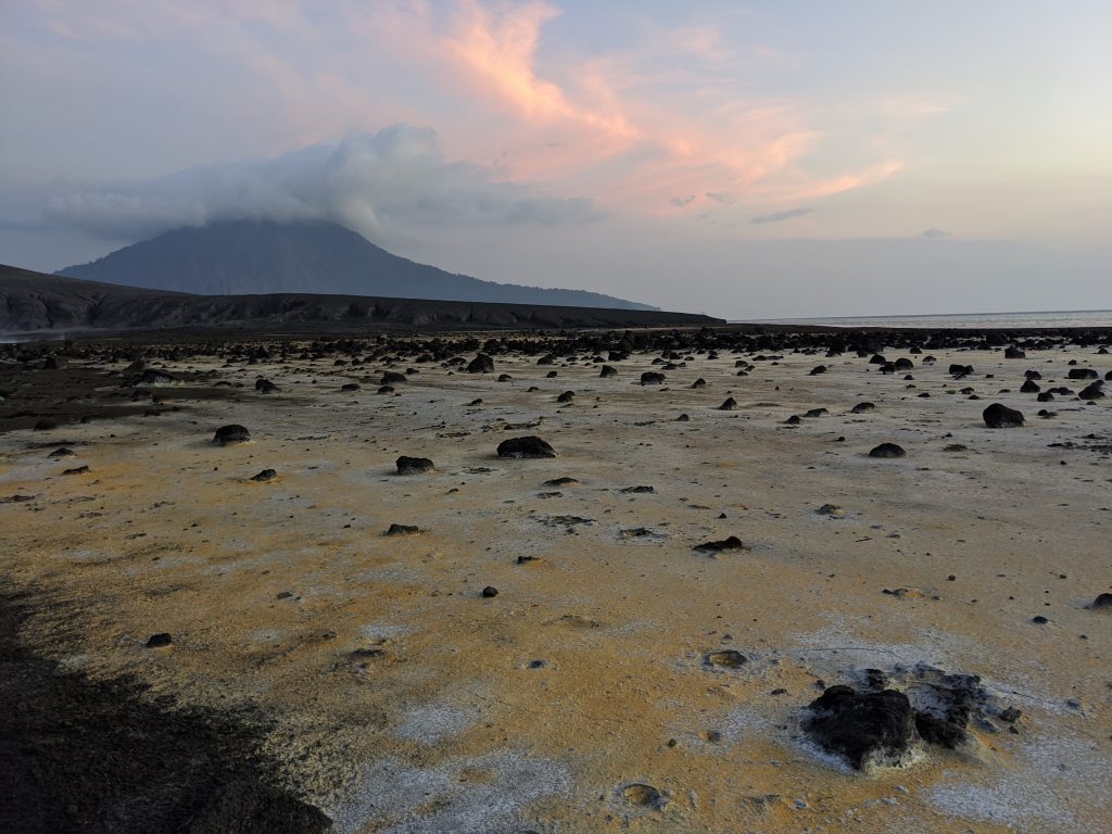
The crater floor was like being on the surface of Mars. Stunning colors, formations and of course, littered with lava bombs in every direction.

That afternoon, we had an amazing show of eruptive activity, captured below. I must admit, we were very exposed in capturing this footage. I had scoped out an exit path just in case the big one came.
On our final morning, we sailed into and around the bright orange discoloration in the ocean. This is a result of recent iron-rich discharge from the volcano. Fascinating stuff!

Anak Krakatu post eruption and tsunami was completely foreign to us. Even with past visits, nothing seemed familiar and that we were again in uncharted territory. To this day, we are still lost for words to describe the destructive transformation we witnessed.
Days after our visit, a series of big eruptions rocked the island, forming a new cone within the lake. Whilst, I count my lucky stars every day, I feel we’ll be back again soon to observe and document this forever changing environment.