Thanks to Sergei Kriukov / Unity Airlines and Philipson Bani we now have some incredible footage and images of Manaro Voui Volcano’s latest phase of eruptions.
As of late February 2026, the Manaro Voui Volcano on Ambae Island, Vanuatu has entered a significant new eruptive phase, prompting authorities to raise the Volcanic Alert Level to Level 3 (Minor Eruption). This escalation follows a period of heightened unrest that began in late 2025 and intensified throughout January and early February 2026. Activity is concentrated at the central tephra cone within Lake Voui, where an existing vent has been producing continuous ash emissions reaching heights of almost 5000 metres (VAAC Wellington). Satellite data from February 24, 2026, has detected extremely high levels of sulphur dioxide and moderate thermal anomalies (Mounts Project, ESA). While the eruption is currently classified as minor, the hazard zone has been expanded to a 3-kilometer radius, and local residents are dealing with significant ashfall and the threat of acid rain affecting water supplies and crops.
This eruption has thus far begun with gas-driven fire fountaining (Feb 12-13) and subsequently transitioning into a sustained ash-producing phase.
The following ground-level images were documented by Dr. Philipson Bani, a volcanologist whose expertise is vital for interpreting such high-risk environments. It is imperative that the public maintains a safe distance and does not attempt to approach the crater; the current Level 3 Alert signifies a minor eruption phase where conditions can shift violently without warning. Dr. Bani’s specialised training and equipment allow for this level of close-range observation.
Eruption image taken on Feb 21

The image shows intense lava jetting and fountaining at the base of the active vent. This activity is driving plumes of ash and steam thousands of meters into the atmosphere.

Notably, the area surrounding the vent has undergone a rapid change, built up by a heavy accumulation of tephra deposits. This structural growth and the sheer force of the incandescent jets are strongly suggestive of a more significant fire fountaining event earlier in the eruption phase.

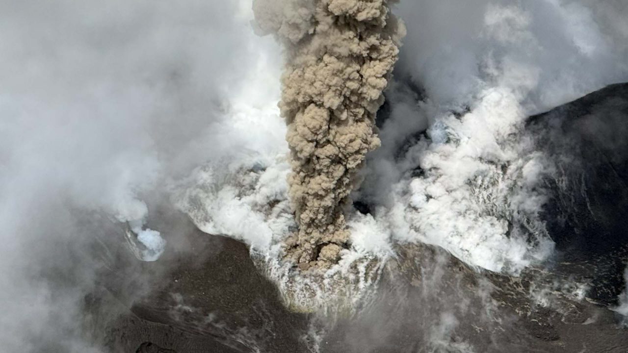
Ash plume rising above Ambae and drifting southwards.

In the aerial footage (taken a week later), we can see a vertical column of brown/grey ash and tephra. It’s dense and cauliflower-like in texture, indicating a high-pressure, explosive release. Surrounding the main ash plume are large blankets of white and blue gases, most of which are a combination of water vapour, sulphur dioxide and other gases. Satellite data shows very high to extremely high sulphur dioxide emissions from Ambae, with levels estimated at approximately 6,000 tons per day (ESA/Copernicus Open Access Hub.)

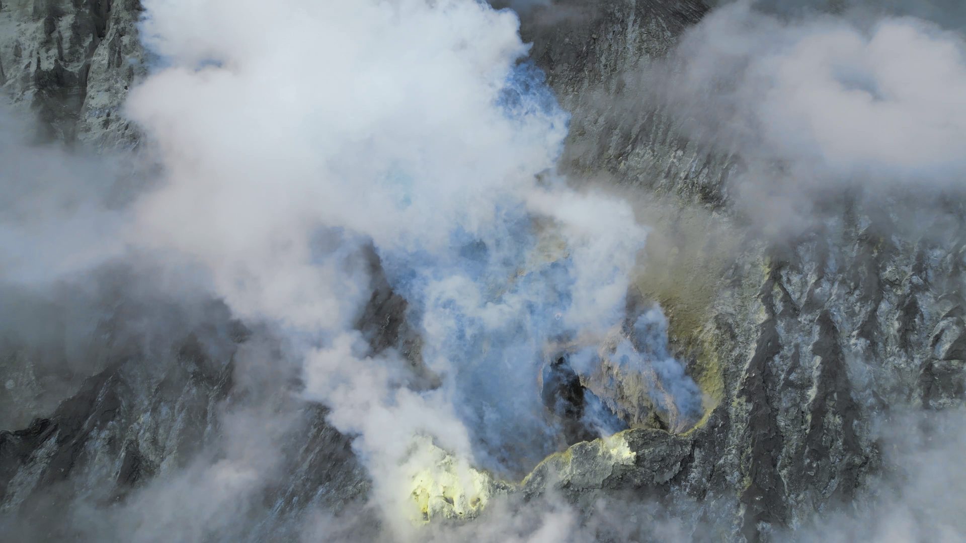
The main active vent is located on the southeastern flank of the tuff cone formed during the 2017–2018 eruptive period. This active vent is situated outside the primary central summit crater. During our most recent observation, clear footage of this vent was captured emitting high levels of SO2.
The source vent of the current ash column (captured in 2025).
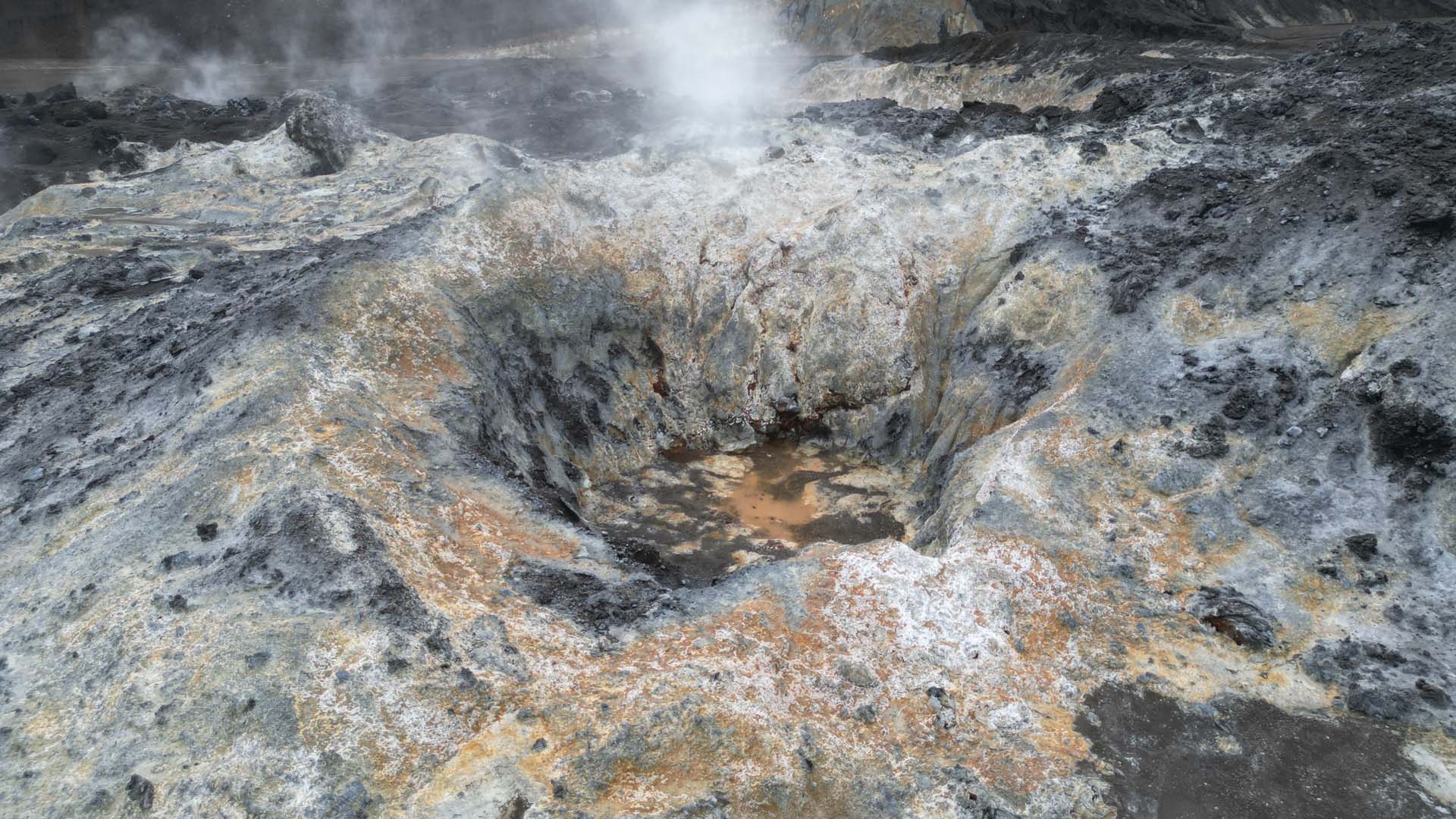
Prior to this eruption, much of the eastern crater floor featured numerous hydrothermal vents and craters, surrounded by altered ground coated with sulphur, silica, and iron oxide minerals. These features have since been buried under an accumulation of tephra and are no longer visible in the most recent footage. However, they were successfully documented by us in detail during previous observations prior to being covered by the current eruptive deposits.
Hydrothermal vents and craters (captured in 2025) that are now buried under tephra.
While the presence of fresh lava flows cannot be entirely ruled out, none are currently visible in any of the footage.
It should also be noted that since 2021, the volcano has effectively transitioned into an open vent system. The water in the central vent area of Lake Voui has been displaced by the growing cinder cone, meaning magma now interacts less with lake water (reducing phreatic explosions) and instead erupts as direct lava or ash.

False Colour (Urban) – Sentinel 2 Satellite Image, showing a hot spot.

For the most accurate and up-to-date information, please refer to the Vanuatu Meteorology and Geo-Hazards Department (VMGD).
Latest images and video are credited (and used with permission) to Philipson Bani & Sergei Kriukov / Unity Airlines.