Three years ago, I finally made it to Iceland and loved every second of it. Parts of it felt like home in New Zealand, but the geology was on an entirely different level. An absolute dream for someone like me. Even with six weeks, I barely scratched the surface, so I knew I’d be back to tackle the Highlands and West Fjords.
In mid-September 2025, I began the long haul to Reykjavik via Qatar, Copenhagen, and the Faroe Islands. The plan was split into two: first, a hiking and exploration stint through the Highlands and West Fjords with my mate Paul. Then, meeting up with Grant to chase the Aurora while driving the Ring Road. I’ve put my favorite shots from that second half in a separate Aurora 2025 post here.
Fresh off ten days in the Faroes, Paul and I grabbed our rental and headed straight for the Reykjanes Peninsula. I’ve always wanted to catch a live eruption, but coming from the other side of the world, my timing is usually just off. Even though we missed the fire this time, seeing the fresh lava flows still cooling and swallowed-up sections of the road was incredible. It’s wild to see up close, though walking on it is a nightmare; the surface is like broken glass.
A section of road partially cut off from the encroaching lava


We pulled into the official “volcano ripoff” car park, where you’re charged nearly 10 Euros to dodge potholes that give the nearby craters a run for their money. While the crowds were all following the signs toward Fagradalsfjall, we broke away toward the Sundhnúksgígar eruption site -specifically the area that kicked off in July 2025.
The trek out was dead flat but incredibly boggy. About 4km in, the cone from the December 2023 eruption finally appeared on the horizon, and another 2km past that, we got a clear view of the July 2025 site. It was a bummer not to see it actually flowing, but I managed to fly the drone all the way out to capture the scale of it.


After checking out the volcano, we stuck around the Reykjanes area to track down some of the lesser-known lava caves. (I’ve put together a dedicated post for those here).
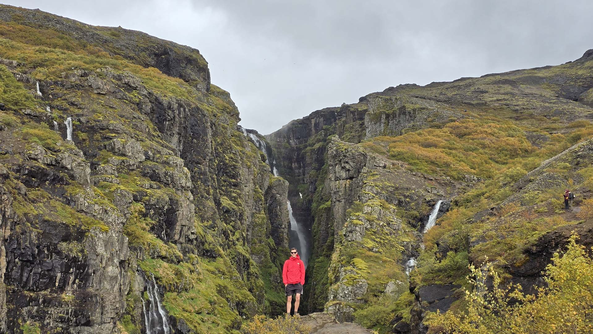
Next up was the Glymur Waterfall hike, which is honestly one of my favorites in the country. It’s a fairly easy loop that leads you to one of Iceland’s most massive falls and a deep, narrow gorge. Doing it in autumn is even better. The colors are incredible, and it’s a dream for drone shots. While most people hike up and double back, it’s much better to do the full loop by crossing the river at the top and heading down the opposite side. The water is ice-cold, but we’re used to it.
We pushed further west toward the Westfjords. The weather was holding up beautifully, so we scouted out another hike and found a stunning lake called Vatnsdalsvatn. The trail climbed high along a ridgeline before zigzagging down to the water’s edge. Being well off the beaten track, we had the place to ourselves. Just total silence and incredible scenery. The wild blueberries were out in force, too, and we definitely overdid it on those. Even though it was only about 8°C, I couldn’t resist a quick swim. The water was freezing, but it felt amazing. We also squeezed in a short trek from Flókalundur up to Helluvatn, but it was so windy at the top that we didn’t hang around for long.

The next day, we headed out to the westernmost edge of Europe, stopping first at the white sands of Rauðisandur. It felt pretty surreal seeing a pale beach in Iceland, but the contrast against those towering dark basalt cliffs made for some incredible shots.

Another white sandy beach near Patreksfjarðarflugvöllur

Látrabjarg marks the westernmost tip of both Iceland and Europe. It’s a long, bumpy road to get out there, but definitely worth the effort. We took the trail along the cliff tops toward Innri-Barðsvogur; it’s a beautiful stretch, and I imagine it’s teeming with puffins in the summer. That said, having just come from the massive cliffs in the Faroe Islands, these didn’t feel quite as jaw-dropping by comparison.
Definitely not a cheesy tourist….


As we pushed further north, the distances became massive. Most of the roads were unpaved, and making any real progress meant winding in and out of endless fjords. While the scenery was decent, it started to feel a bit repetitive, with the notable exception of the drive along Bíldudalsvegur (Road 63), which was absolutely spectacular.
The real star of the Westfjords, though, is Dynjandi. It totally lived up to the hype. It’s this massive, tiered cascade that looks just like a bridal veil, and the best part is being able to hike right up to the base to feel the scale of it.

With time running out, our final mission in the Westfjords was the hike up to Drangajökull. For me, this was the highlight of the entire region. The valley is stunning and felt completely untouched by the usual tourist crowds. We made it all the way to the mouth of the glacier, but a massive torrent of water was gushing out, so we couldn’t actually step inside.


Looking back, the Westfjords were nice, but if you’re short on time in Iceland, I wouldn’t try to squeeze them in. The driving distances are huge, the scenery gets repetitive, and it honestly wasn’t as dramatic as we expected.
For the next leg, we headed into the Highlands. Just a heads-up: you legally need a 4×4 to drive any F-roads in Iceland, which covers most of this region. We actually entered from the north via Road 35- technically not an F-road, but given how rough it got, it probably should be. We even hit our first snow of the trip, which is pretty standard for late September. Still in shorts, though, obviously!

The road isn’t steep, but it’s absolutely hammered with potholes. There’s more crater than road at this point. The landscape opens up into a massive volcanic desert, with mountains and volcanoes punching out of the horizon in basically every direction.

Along the way is the Hveravellir Geothermal area and well worth the stop. There’s a great variety of surface features here and some hiking trails. We only had time for a one hour loop to a small lava cave, but there are much better features further south if you have time.


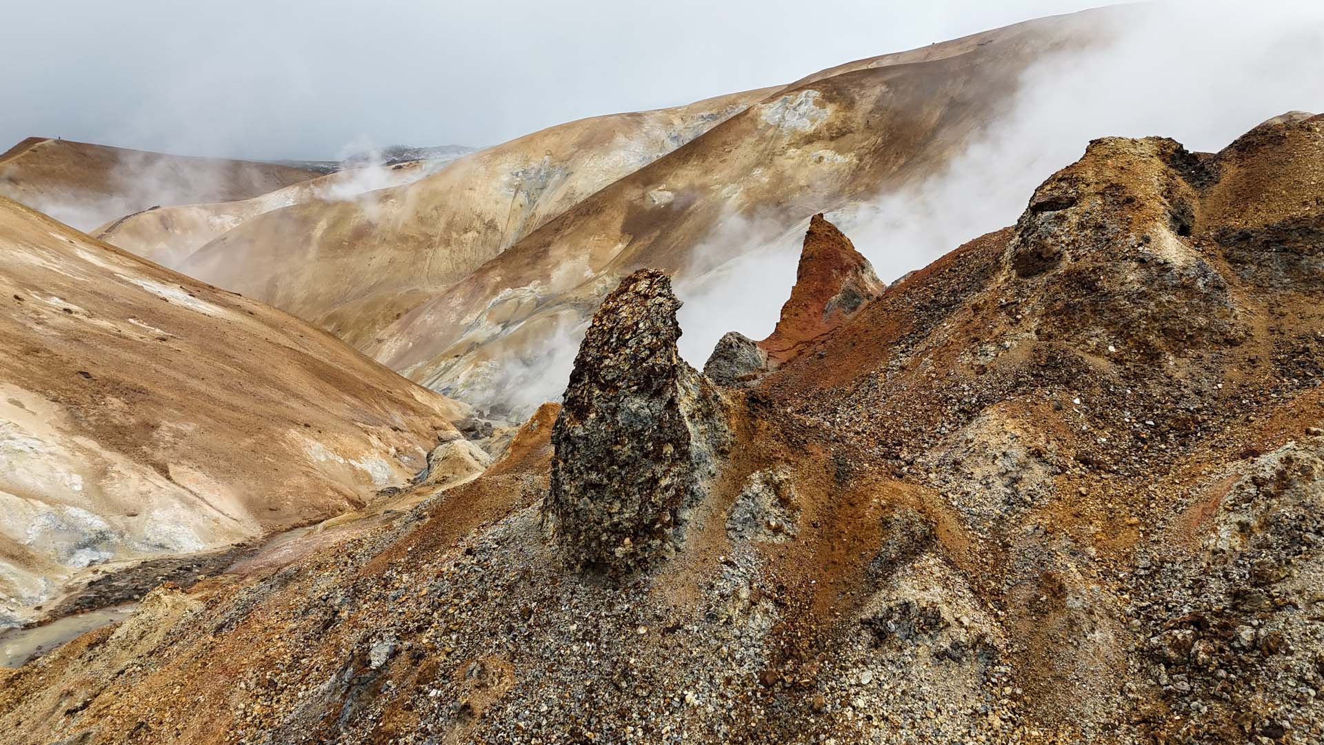
Heading further south, we finally reached a place that’s been on my bucket list for years- Hveradalir. The name translates to “Valley of Hot Springs,” and it’s located in the Kerlingarfjöll mountain range. The sheer concentration of rhyolite creates an unreal landscape of rust-red, yellow, and orange peaks. Thick plumes of steam hiss out of the earth, with patches of blue ice that never quite melt. It’s a bizarre, high-contrast world where you’re shivering in the freezing mountain air while the ground beneath your boots is literally boiling. I fell in love with the place instantly and it’s easily in my top five locations in all of Iceland. Just keep in mind that getting there is a mission and absolutely requires a 4×4. It was the perfect finale for the first leg of the trip, and a great spot to wrap things up with Paul before he headed off and I met up with Grant for part two.


This section covers our daytime adventures only. If you want to see what we got up to after dark, check out the post on our night aurora adventures here.
It was sad to see Paul go, but I had a fresh adventure ahead with my aurora-chasing buddy, Grant. This was his first time in Iceland, and he was completely blown away. Unlike the first leg of the trip, the weather was now calling the shots. We knew we wanted to complete the Ring Road, but we had to chase clear skies to have any shot at the lights. After obsessively studying weather models, we decided to head for the Snæfellsnes Peninsula.
On the way, we stopped at Gerðuberg to see the massive basalt columns. It was incredibly windy, but I managed to get the drone up for a few shots of some funky clouds hugging the mountains in the background. We also made a stop at the Selvallavatn waterfall, where I scrambled up a nearby volcanic cone to get a better look at the landscape.

One of the biggest draws on the peninsula is Kirkjufell. I’d already climbed it during my last visit, so this time was more about making sure Grant got his shots. Unfortunately, the bridge at the top of the falls was under construction, which forced us to wade across the freezing river to reach the other side.

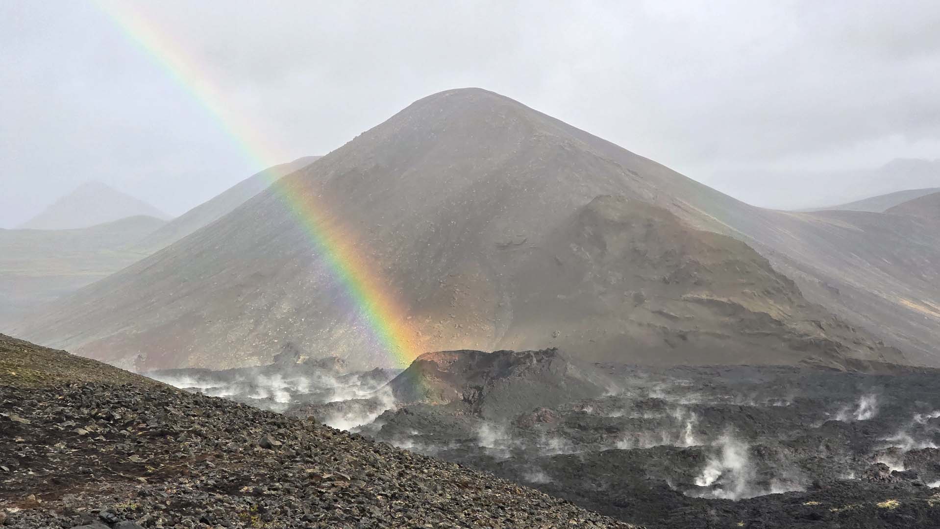
Other highlights included the striking basalt arches of Gatklettur and a hike out to the volcanic cone of Búðaklettur. The day felt even more cinematic when we caught a perfect rainbow framed right in the middle of a valley.


It was at this point that we had to make a critical call. Our original plan was to tackle the Ring Road clockwise, and we already had a rough itinerary and guesthouses booked. However, a massive weather front was moving in, and if we had stuck to the plan, we would have been chased by storms all the way across the country.
The only logical move was to flip the script – head back south and start the Ring Road in the opposite direction. I spent most of the morning frantically cancelling and rebooking accommodation, but it paid off. We ended up with incredible weather for the rest of the trip. Most of the following day was spent behind the wheel, making our way to the south coast. A major highlight was Sólheimajökull, where we even managed to scout out some impressive ice caves tucked into the glacier.


At Skógafoss, the spray is intense. What you don’t see in this shot are the hundreds of tourists huddled together just in front of me, too afraid to venture any closer for fear of getting drenched.

When we arrived in the seaside village of Vík, we decided to check out the Katla Ice Cave. Having explored many of Iceland’s blue-ice caves in the past, I found Katla a bit underwhelming by comparison. It was scenic enough, but it wasn’t really a “cave” in the traditional sense. More like a small opening in the side of the glacier. That said, I still managed to walk away with a nice photo.

Sticking with the ice theme, I spent an entire morning solo exploring the Skaftafell Glacier. My wandering paid off when I stumbled upon another incredible ice cave…one that I was likely the first person to ever step inside.


Another glacier followed – Svínafellsjökull Glacier and then Múlagljúfur Canyon afterwards.


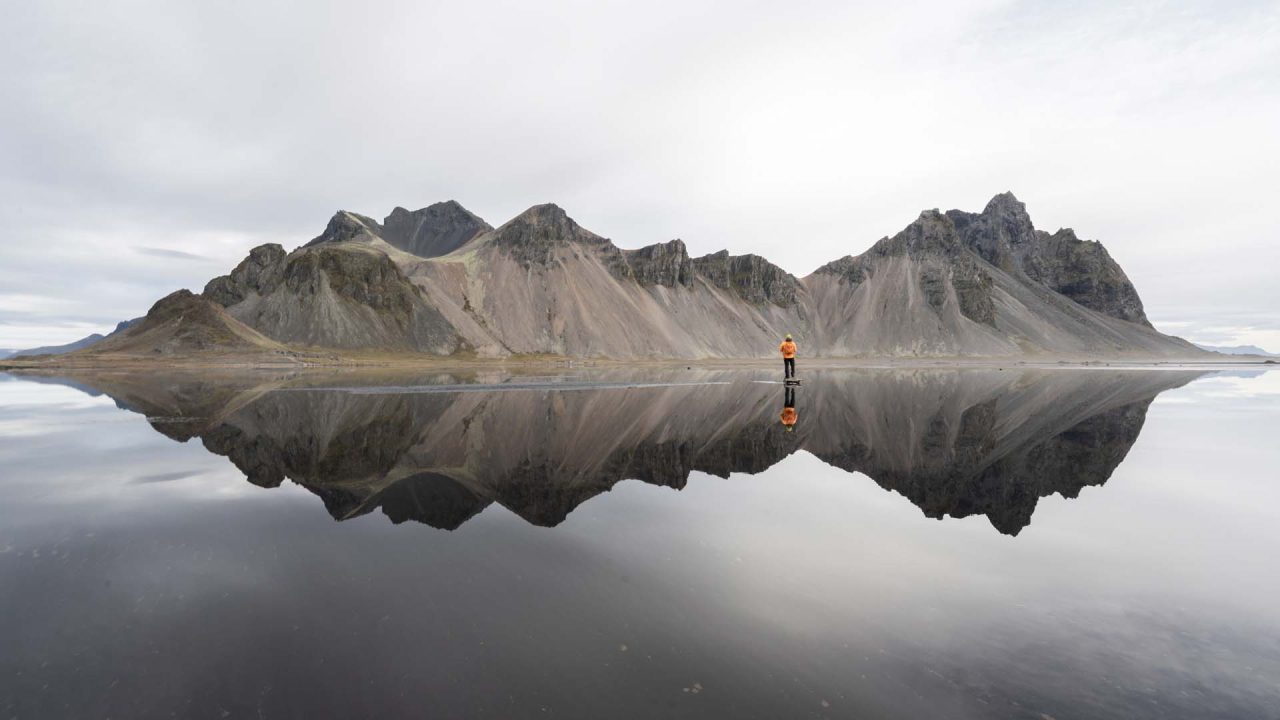
One place I missed out on during my last trip was Vestrahorn. To really see it at its best, the conditions have to be flawless, specifically zero wind to create that perfect, glassy reflection. We got exactly that. Grant and I were the only ones brave enough to venture out into the middle of the wet sand. It meant getting our feet soaked, but since mine were already wet most days from crossing rivers and scouting glaciers, it didn’t really matter. It was easily one of the absolute highlights of the journey.

From Vestrahorn, we pushed into the north of the country toward my personal favorite waterfall, Dettifoss. As the most powerful waterfall in Europe, the sheer scale and volume of water thundering over the edge is absolutely staggering.

Not far from Dettifoss lies another Icelandic gem: Hljóðaklettar. It’s a surreal collection of columnar basalt created when a massive volcanic eruption was flash-cooled by the ancient Jökulsá á Fjöllum river. That rapid cooling forced the basalt to fracture into chaotic, swirling honeycombs and radial patterns. I spent a long time just wandering through the area, trying to wrap my head around the wild geological forces that sculpted these formations.


Hverir is definitely worth the stop, even if it’s packed with tourists all complaining about the intense smell. To escape the crowds, I hiked up a very steep trail and was rewarded with some incredibly cool mud pots right at the top.

For geology buffs, Leirhnjúkur is an absolute must. It’s an active geothermal field and lava flow tucked within the Krafla caldera, sitting directly atop a magma chamber. The area was transformed by the massive “Krafla Fires” of 1974–1984, which left behind vast, jagged fields of black lava that are still steaming to this day.


By this stage, we were both completely exhausted. We had survived on virtually no sleep for two weeks, staying out until 3:00 or 4:00 AM most mornings to capture the Aurora. It was finally time to start the push west along the Ring Road before turning south toward Reykjavík.
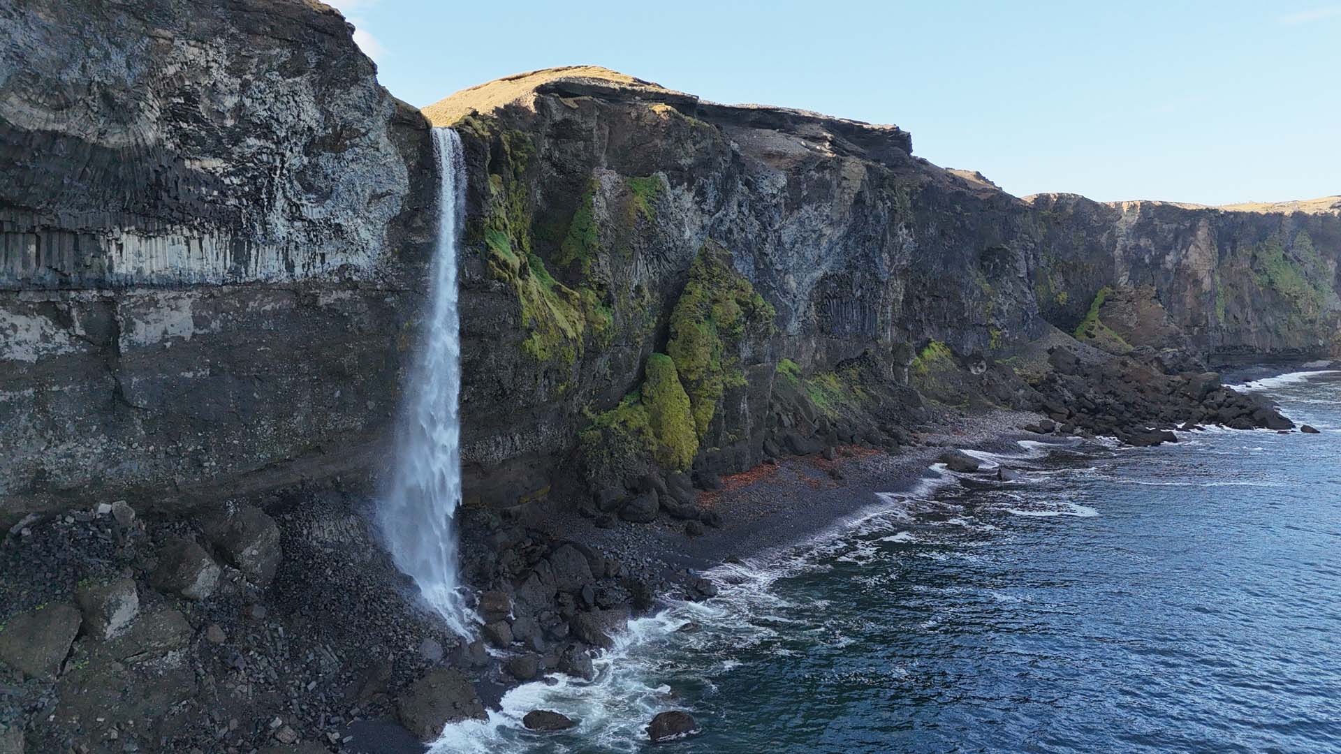
Along the way, we made stops at the massive Ásbyrgi Canyon and Botnstjörn Pond, as well as Goðafoss and Sjónarhorn. Just as we thought we were finished, I spotted a clear weather window near Blönduós, so we decided to squeeze in one final night of aurora chasing. We took Route 745, which winds right around the tip of the peninsula, and discovered some incredible hidden gems along the way. Sometimes, simply following a river with the drone pays off. It led us to some stunning waterfalls cascading directly into the ocean below.

I event stumbled upon a stunning wall of columnar jointing hidden in the middle of nowhere. It doesn’t even have a name on the map!


We had a wonderful night filming the aurora before heading back to the airport where Grant departed back to New Zealand. I was lucky to have a couple of extra days, so picked up yet another rental car and made my way back to explore Fagradalsfjall, Meradalir and Litli-Hrútur. It was cold and the weather wasn’t the best, but there wasn’t a single person around, so I was free to explore such a wonderfully rich site all by myself. It was bliss.


It was an incredibly hectic trip with almost no sleep from start to finish, but Iceland never fails to leave me in awe. The landscapes are so profoundly impressive that no matter how exhausted I get, I simply can’t get enough of this place.