Te Kopia is located 40 kilometres south of Rotorua and is situated along the Paeroa Fault scarp. The reserve’s geothermal system is part of the larger Taupo Volcanic Zone.
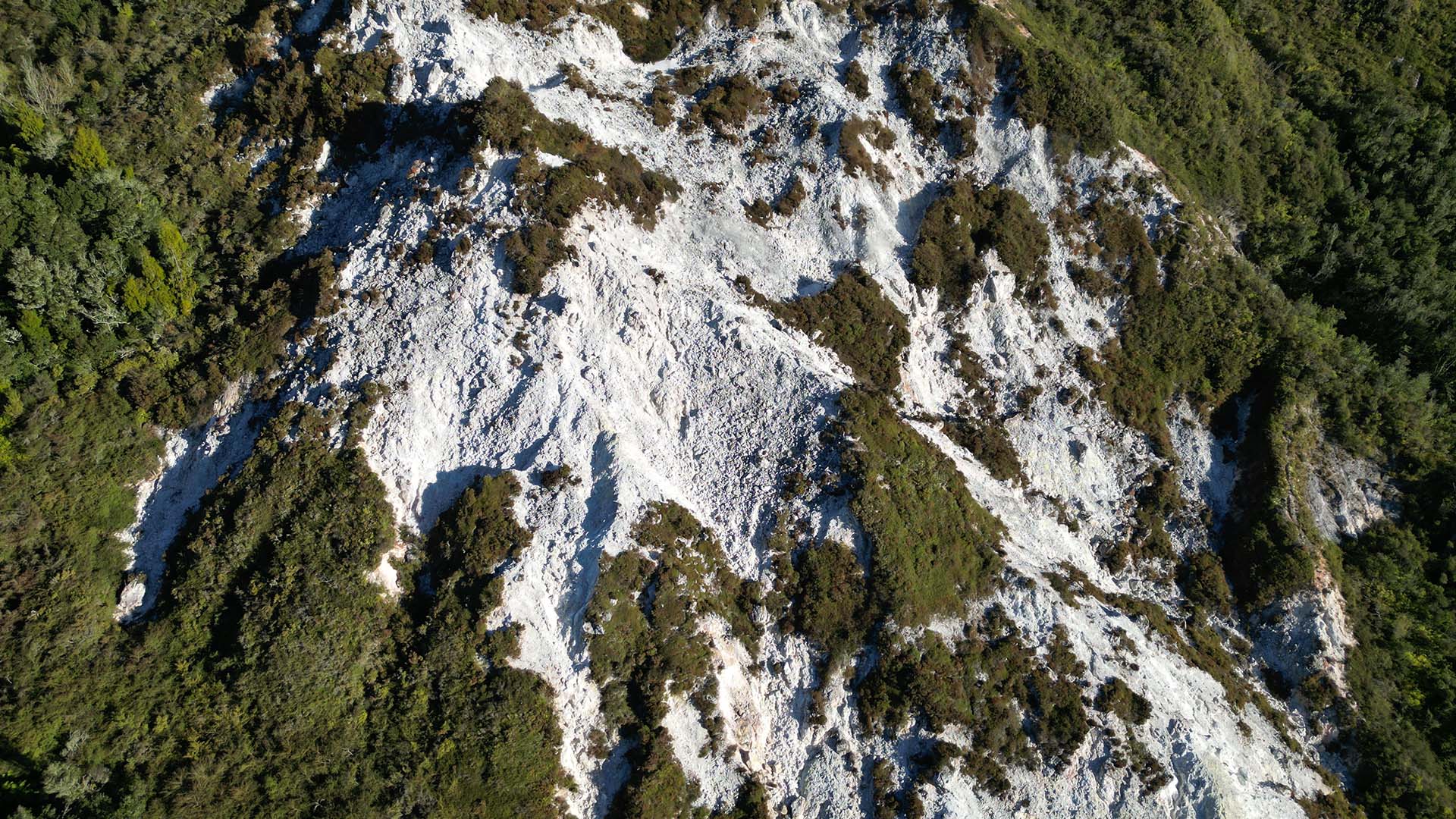
Dominating the landscape is the Te Kopia scarp – the visible face of the Paeroa Fault. It wasn’t created by a single event, but is the result of thousands of individual earthquakes over hundreds of thousands of years. One massive block of land (the Paeroa Range) stayed relatively high, while the block to the west (the Reporoa Basin) dropped down. Each time the fault slipped during an earthquake, the cliff got a little bit taller. This wall of rock is roughly 500 metres high.
The scarp is constantly being weakened. The acidic steam turns the hard volcanic rock of the cliff into soft clay. This makes the scarp geologically unstable, leading to frequent landslides and slumps where the cliff face collapses under its own weight.
The scarp gets its distinctive white color from silica deposits and hydrothermally altered rocks. The steam venting out of that scarp is high in hydrogen sulfide. When it hits the air near the surface, it turns into sulfuric acid. This acid is incredibly aggressive and eats away at the dark minerals in the rock (like iron and magnesium) and leaves behind a skeletal remains of white silica and kaolinite clay.
A section of the Paeroa scarp that is permanently steaming, with ground temperatures reaching 90–100°C just below the surface.
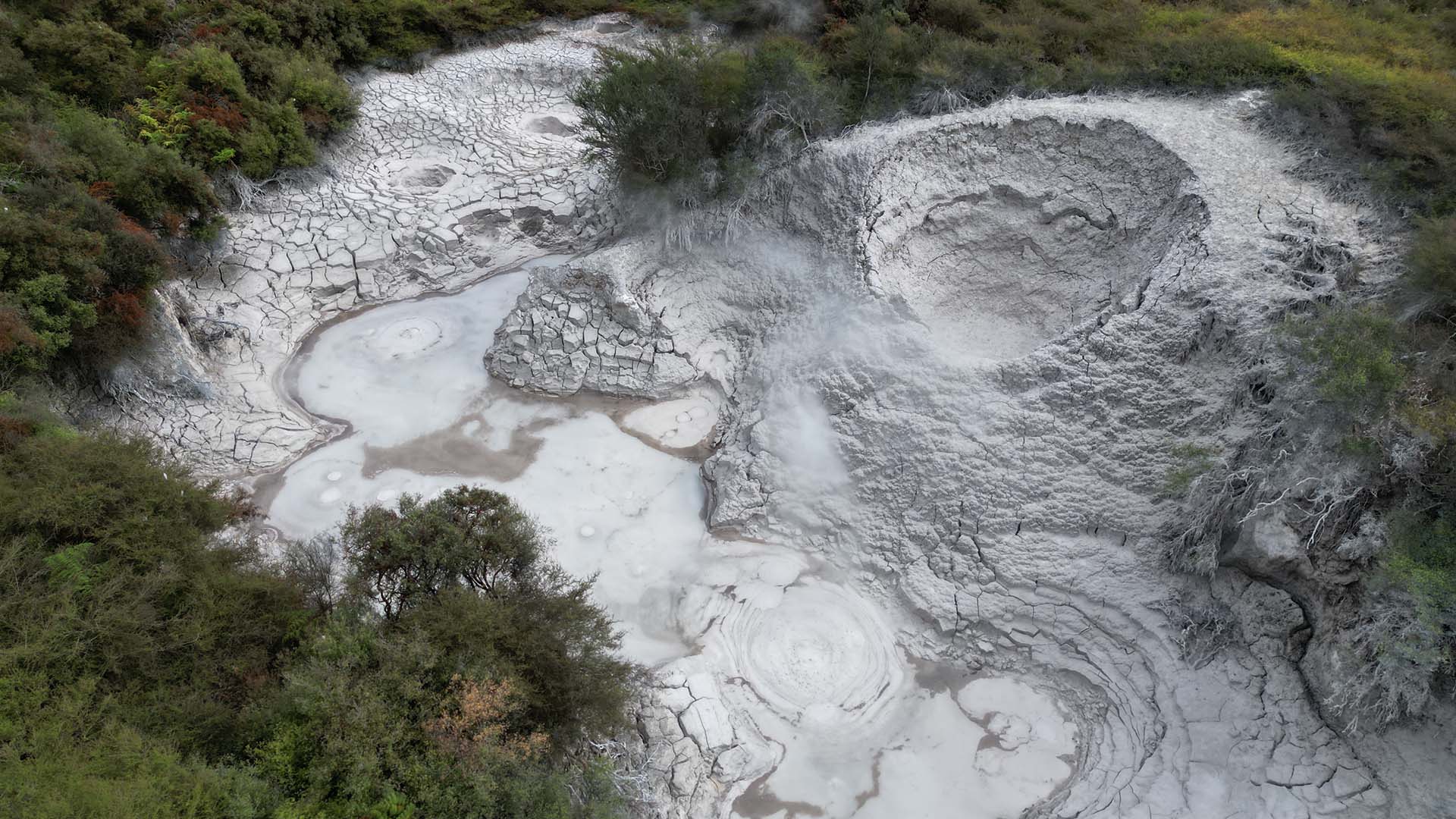
The scenic reserve, located at the base of the scarp and open to the public via a short boardwalk, has a number of surface features.
Four main acid-sulfate lakes exist, with the largest being the eastern lake that stretches 75 metres across. It usually looks relatively still, with a milky blue tint caused by fine clay particles suspended in the geothermal water. However, there is constant mud upwelling, where gas and steam from deep underground push thick, grey plumes to the surface. The lake’s water level isn’t fixed, often rising and falling by about a metre.
The eastern lake (relatively high water level)

The eastern lake (relatively low water level)

The western lake is the second largest, measuring 40 metres wide. In the far western rim of the lake is the Te Kopia Mud Geyser. The geyser is one of the largest and most active mud geysers in New Zealand. Unlike traditional water geysers, mud geysers erupt a mixture of hot water, steam, and mud. This geyser doesn’t follow a predictable schedule like some other geysers around the world. Instead, its eruptions can be sporadic and vary in intensity. When active, the geyser can eject mud and steam several metres into the air. The constant activity of the geyser has created a distinctive one sided mud mound formation around its vent. After a period of relative inactivity, the geyser reactivated mid-2024 due to a consistent drop in the mud pool’s water level. Eruptions happen irregularly – around two each hour, with mud jets reaching around 2 metres in height. Update: As of February 2026, the water level has again risen due to a major rain event hitting the area and the mud geyser is no longer active.
The mud geyser erupting
The western lake and one sided mud mound formation

Close up of the geyser vent

The southern lake shifts between a body of water and a dry mud pool depending on the season. Ranking as the third largest at 40 metres wide, the area is defined by a cluster of small mud volcano cones, none reaching more than half a metre high. There area also several bubbling mud pots scattered across the depression.
The southern lake

The last and smallest (but most active!) of the four main lakes is the northern lake. It features several distinct mud fountains, or perpetual spouters, that splash mud about half a metre high without pause. Unlike the geyser that builds pressure for a timed eruption, these spouters have an open plumbing system, allowing them to spray constantly as long as there is enough steam pressure. This keeps the entire lake surface in a state of restless, constant motion. The lake also features a large, circular mud cone topped with a deep, bubbling crater. The sheer size of the mound suggests it likely erupts much like the nearby mud geyser, slowly building its height over time through successive bursts of mud. It is one of the largest geothermally driven mud volcanoes in the country.
The northern lake’s perpetual spouters.

The northern lake (very dry, low water level) and large mud volcano.
Beyond the four main lakes, the reserve is dotted with various other features, including an orange pool that looks entirely out of place. This vivid colour is a shift in chemistry, where iron-rich minerals have oxidised and collected in the water.

At the western end of the reserve, the landscape is scarred by several hydrothermal eruption craters, marking spots where trapped steam pressure once built up and violently blasted through the earth’s surface.

Mud pots near the eastern lake

Please note that many of photos shown here were taken via drone. When visiting, always stay on the marked tracks. The ground in geothermal areas can be deceptively thin and unstable, and the surrounding crust is often dangerously hot.