
Ambrym Island, Vanuatu / August 2015
I had been surfing YouTube when I came across footage that blew my mind. A lake of lava the size of two football fields, churning away at the bottom of a massive volcanic crater. Seeing this immediately reignited my passion to travel. I had become bored of “tourist” holidays and this footage conjured up adventurous thoughts something akin to a modern-day version of Indiana Jones.
A few hours of research later I had this location mapped to the centre of a heart-shaped island called Ambrym, an island renowned for black magic. Satellite images showed two giant craters within an ancient caldera, entirely surrounded by dense jungle. A few months earlier, it had erupted, then a Cat 5 cyclone hit. This wasn’t going to be easy.

I messaged two friends – Dan & Nicole and the next day we were in a pub, mulling over plans to get as close to this fiery pit of molten lava and survive to tell our story. A plan was made to fly to Port Vila and onto Craig Cove, a small airport on the western end of the Island. We managed to track down a number for a local guide named John. After waiting two days, we finally got a response “No problem brother”. He said he’d be waiting at the airport for us. And with that, on August 21, 2015 we boarded Flight NZ 788 from Auckland to Port Vila – a journey that filled us all with great suspense and uncertainty.
Port Vila was hot and muggy. We boarded a taxi and checked in to Fatumaru, a comfortable lodge on the outskirts of town. Downtown Vila was a mix of traditional markets and modern shops. Hoards of mini buses desperate to take you anywhere clogged the streets.

We spent the next day exploring Efate Island with the popular “around the island” tour. First stop was the Mele Cascades, a secluded swimming spot of pools and waterfalls and then onto the Blue Lagoon and Eton Beach. It was well worth it, but felt I was falling back into the “tourist” holiday again. That was all about to change.

That night I reviewed all the geological data of Ambrym. Nervous it could erupt again, I had been carefully following seismograms, gas output and thermal anomalies. I noticed the SO2 output was up significantly and it made me more nervous than ever. I asked the guys if we were being stupid and should we change plans and visit the most tourist friendly volcano of Yasur? Our indecision was killing us, but ultimately time ran out and our original plan stuck.
It was still dark when we left the Fatumaru Lodge bound for the airport. The domestic terminal was an antiquated room with three check in counters. We found a sign “Craig Cove” and checked in. Nothing much was said – the usual questions seemed irrelevant. Our handwritten boarding pass was issued. Seat 1C.
The aircraft was a Harbin Y-12 that looked 30-40 years old. My safety concerns were not helped when the only information card in the seat pocket was a kind request not to graffiti. The pilot gave a single look over his shoulder and we were off without any safety briefing. Approx flight time 45 mins.

We passed over the islands of Emae and Epi and could also see Lopevi, a beautiful volcanic island I want to climb sometime soon. Then Ambrym came into view. Thick clouds shrouded the summit. We made a hard turn to line up with the runway and after a bumpy landing, we had touched down at Craig Cove. The tar sealed runway from WWII was now mostly gone and replaced with a mix of grass, sand and coral. Over 50 locals had gathered around the runway to welcome us, including John, our guide who was waiting with his wife and three children – and a truck to take us to his village.

The Island was beautiful. Lush jungle, black sand beaches and dramatic hardened lava flows to remind us that danger was around every corner. Ten minutes into our journey, we punctured one of the truck tyres. Just when I thought we’d be walking, out comes a bicycle tyre repair kit. After multiple attempts at fixing, it seemed to hold and we were on our way again.

An hour later, we arrived at John’s Village of Port Vatu. A quiet village on the coast, home to about 70 people. He offered us his bungalow, but after seeing the hand sized spiders, ticks and hearing of snakes, scorpions and other nasties, I opted for the safety of my own tent.


Once settled, we discussed a plan with John. At first light tomorrow, we’d set off to climb to West Camp – a small camping area on the outskirts of the ancient caldera, before hiking to the Benbow summit to view the lava lake. The other, larger crater of Marum was too dangerous as it only just erupted and there was a high probability it would erupt again.
Sleeping in a tent at night was unbearably hot. But it was a small tradeoff compared to all those nasties lurking around the jungle just behind us. I finally fell asleep with a great sense of trepidation for what would lie ahead.
The next morning, we were up early to an island breakfast of fruit and taro. After a few final gear checks, we were on our way up the volcano. The first part of the trek was relatively flat through gardens and other small villages. This led onto a lava flow from 1913 which we followed for an hour or so. John explained to us that this eruption was due to a black magic spell that was placed on a village. As it headed down the western side of the island, the chief of this village placed a counter-spell and at the last minute, the lava flow took a turn to the left and spared the village.


It wasn’t long before we were in the jungle and traversing up a river bed. It was hot and humid and the bugs were out in force. A tick had attached itself to Dan which proved a mission to remove. At this state, we had reached the halfway point, only to find our porters had raced ahead with our food. So it was one tin of tuna and some breakfast crackers between us all.


The track became steeper as we neared the caldera. Sulphur was in the air and the excitement built. One final push over the ash dunes and we were gobsmacked at what we saw. A massive caldera with two smoking cones of Benbow and Marum. It looked menacing, but all I wanted to do was get closer.

We set up camp at West Camp, a basic campsite with a shelter and bush toilet. A lunch of rice, tuna and bush salad was prepared. During lunch John mentioned that we’d head to Benbow late afternoon to see the lava at night.


I checked my GPS, camera, gas mask and locator beacon and departed West Camp at around 4pm. We hiked over the caldera, an incredible mars like landscape dotted with flowering orchards. There was no marked track, but John seemed to know exactly where to go. About an hour passed before we hit the crater wall – a very steep climb up scree and often very precarious. One slip and you’d be lost down a ravine. It was just starting to get dark when we made it to the summit.

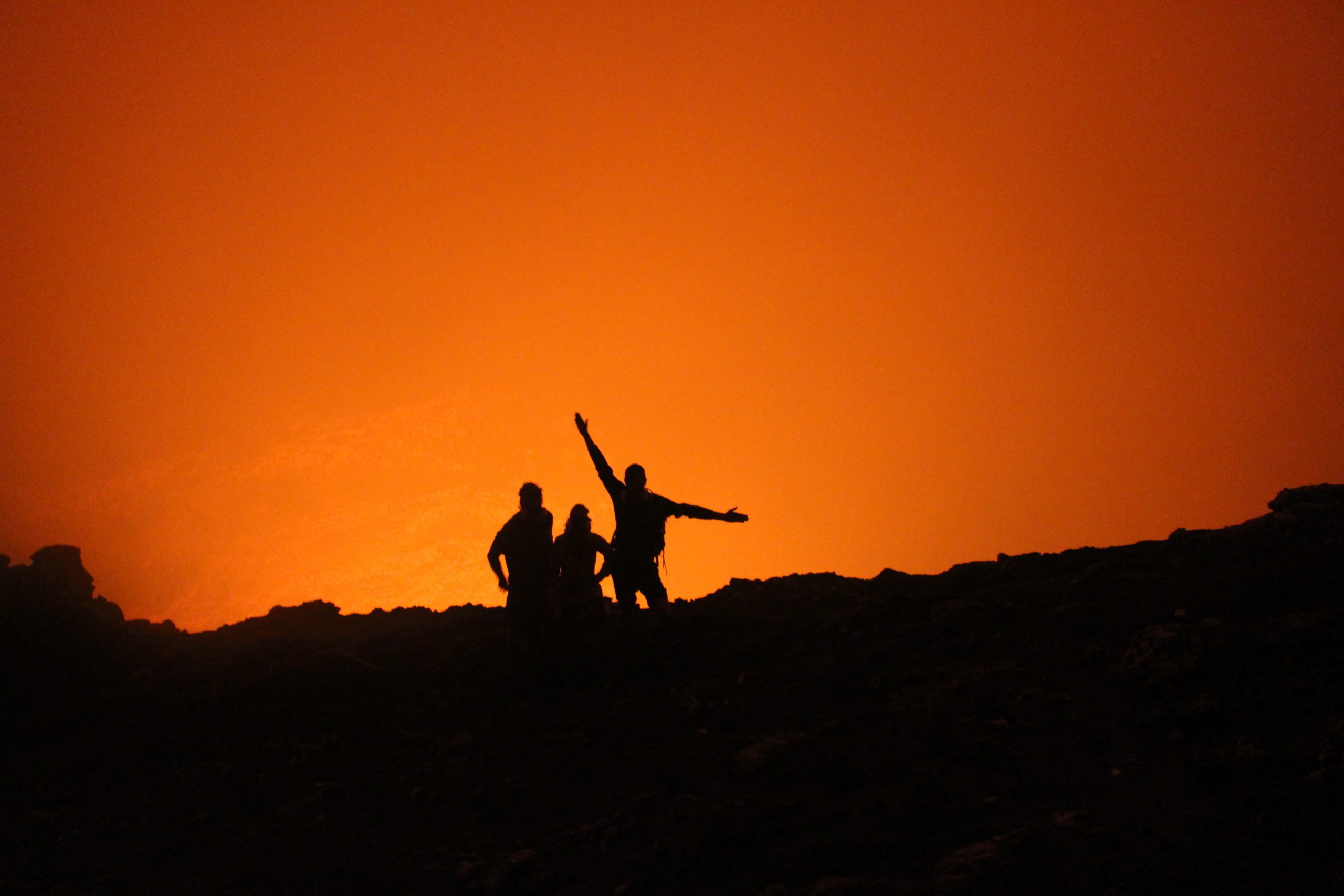
We peered down and could just see a shouldering pit of toxic gases and a faint glow of orange at the bottom. Surely we weren’t going down there?! John looked at us and paused. He then muttered the words “We go down” and “take this stick to help”. We looked at each other, half expecting one of us to say, “nah”! Instead, we slowly followed John down into the crater. It was steep, like really steep and crumbly. We treaded carefully, fearing the lava lake was at the bottom of all of this and would be a very grizzly end if we slipped. The gases were overpowering and the respirator seemed to make very little difference. The red glow was a strange sensation. Our brains were fooling us into thinking it was just a sunset, but it glowed more intensely the darker it got.


After 30 minutes or so, the ground began to flatten off and a brief clearing of the gas did not show a lava lake, but another climb up the inner typhra ring. At this stage, we could hear something that sounded like heavy waves crashing. We carefully made our way up the typhra ring when John stopped us and said “LOOK!”. We looked down and saw our first glimpse of the Benbow lava lake. It was my first time seeing a lake of lava churning so violently and so close. It was mesmerising and absolutely the BEST thing I had ever witnessed anywhere. Occasionally a big pulse of lava would rise, covering the crater floor. There were many “ooohhs” and “aahhhs” that night. We were covered in coarse ash, stunk of sulphur and horribly dehydrated, but were witnessing the best show on the planet. John pointed out a landslide less than 30 meters away. This was the former viewing area, but collapsed during an earthquake only a few months ago. After hearing this, we decided it was probably time to leave and get back to safety.


The traverse out was a hard slog. Back down the typhra ring and up and down the crater wall and finally to the relative safety of the flat caldera.
The next morning, we packed up and hiked back down to Port Vatu for one final night before flying back to Port Vila the next morning.